Plate Tectonics
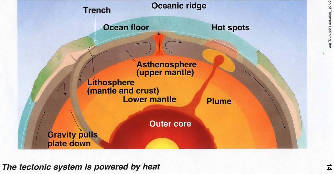
The theory of plate tectonics states that the earth's surface is not fixed, but is constantly in motion. Before we go into detail, let's review the layers of the earth. On the "outside" you have a very thin crust, next is a thick mantle and finally the central core. Tectonic activity is concentrated in the upper 450 miles of the earth. The outer mantle and the crust are stuck together to form the lithosphere. The lithosphere is broken up into pieces, or plates, that butt up next to each other. Directly below the lithosphere is the asthenosphere; a soft solid layer of the upper mantle. It can move extremely slow and the lithospheric plates "float" on top of it. As heat from the core rises into the asthenosphere and circulates in a convection cell, the plates begin to move. This is responsible for continental drift (think Pangaea).
Since the plates are touching their movement causes stress to build up and release. These boundaries are home to the most geologic activity on earth (volcanoes, earthquakes, etc). There are 3 types of boundaries that we will disucss: divergent, convergent and transform.
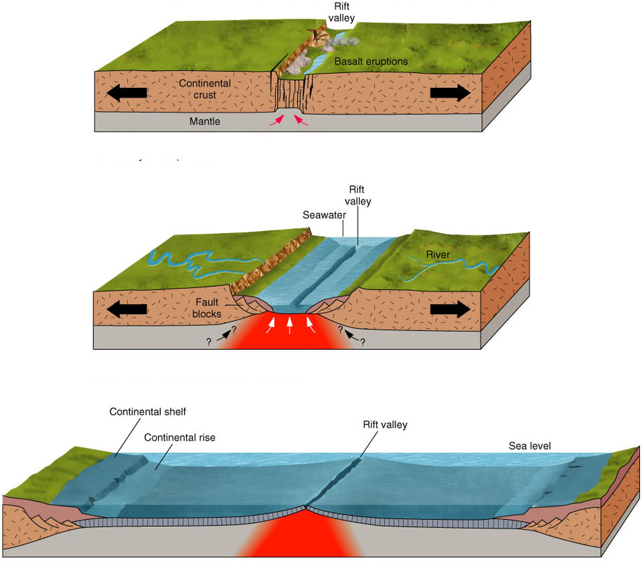
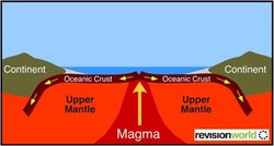
Divergent boundary: This boundary is formed when plates are pulled apart. This forms a narrow valley (called a fissure) and molten rock, or lava, will rise. As the hot lava cools it creates a ridge. This is the location for seafloor spreading which creates more crust. Seafloor spreading is circular in movement. It creates crust at the ridge but crust is destroyed at the trenches (subduction zones). There are 3 types of mid-ocean ridges
Divergent boundary: This boundary is formed when plates are pulled apart. This forms a narrow valley (called a fissure) and molten rock, or lava, will rise. As the hot lava cools it creates a ridge. This is the location for seafloor spreading which creates more crust. Seafloor spreading is circular in movement. It creates crust at the ridge but crust is destroyed at the trenches (subduction zones). There are 3 types of mid-ocean ridges
- Mid-Atlantic Ridge runs down the middle of the Atlantic Ocean and is part of the longest mountain chain on Earth
- East Pacific Rise is the main section in the Eastern Pacific Ocean
- Indian Ridge is an upside-down "Y" shaped structure
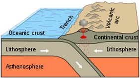
Convergent boundary: This boundary is formed when 2 plates come together. There are 3 types:
- Continental-Oceanic: when continental crust and oceanic crust meet; the ocean crust is heaver and sinks (made of basalt vs. granite. These are subduction zones which form trenches. Earthquakes occur from friction due to the downward lurches. May produce volcanoes on the surface.
- Oceanic-Oceanic: Oceanic crust and oceanic crust meet, the older (cooler, denser) plate sinks; produces undersea trenches and volcanoes. May form an island arc (a chain of volcanic islands) Ex: Mariana Islands near Japan
- Continental-Continental: occurs when two continental crusts meet; forms "wrinkles" on land from pressure; makes mountains (Himalayas)
|
|
|
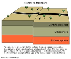
Transform boundary: This boundary occurs when two plates slide past each other. A fault forms where they touch. Since these plates are grinding past each other LOTS of friction is created which means lots of earthquakes. Ex: San Andreas fault in California.
Evidence for Plate Tectonics: How do we know this is real?
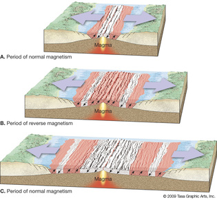
1. Paleomagnetism: "ancient magnetism". Paleomagnetism is looking at the position of the magnetic filings....so as the lava comes out at the divergent boundaries, the iron filings will position themselves to point towards magnetic north - which flips about 180 degrees every 400,000 or so years. You will see strips that mirror each other on both sides of any divergent boundary. They should each represent about 400,000 years worth of growth and should alternate between pointing to the current north and then the current south (which would have been north at the time)
1. Paleomagnetism: "ancient magnetism". Paleomagnetism is looking at the position of the magnetic filings....so as the lava comes out at the divergent boundaries, the iron filings will position themselves to point towards magnetic north - which flips about 180 degrees every 400,000 or so years. You will see strips that mirror each other on both sides of any divergent boundary. They should each represent about 400,000 years worth of growth and should alternate between pointing to the current north and then the current south (which would have been north at the time)
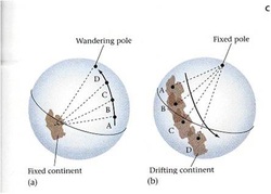
2. Apparent Polar Wandering also deals with magnetic filings but is looking more at the magnetic filings in other pieces of crust (like land masses). Scientists studied the way the filings were pointing in different pieces of crust (and different depths of rock formed from volcanoes that erupted over and over again) and found they were pointing in different directions so they thought maybe the magnetic North Pole "wandered" a little bit and so made the filings point in different directions. But we know that can't happen now and what really happened was that the land masses moved and cooled at different rates (continental drift). So it appeared the poles wandered but actually it was the continents that had moved and were positioned differently in comparison to the North Pole at different times.
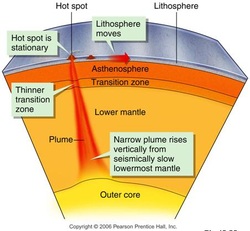
3. Mantle Plumes & Hot Spots: Mantle plumes are columns of magma rising within a plate--not at the boundary. There is a superplume lifting Africa right now. Hot spots are areas on crust where a plume has broken through and it creates a volcano. As the plate moves, the volcano moves off of the plume and becomes dormant. Another volcano begins to form. Ex: Hawaiian Islands
4. Sediment Age: Ideally, sediment should be the same age all over the world; however, younger (and thinner) rock is found at the mid-ocean ridges while older and thicker rocks are found at subduction zones. This suggests that plates must be moving.
5. Oceanic Ridges: Shows site of seafloor spreading, are younger than ocean floor at the subduction zone
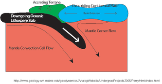
6. Terranes: Land that is scraped off at oceanic crust onto continental crust as it is subducted. No scraping would occur if plates were not moving
